Over millions of years, Earth’s continental plates have slammed against each other to form mountain ranges and have slid under each other to form deep ocean rifts. Rocky surfaces erode and form sediments that then spur changes below the Earth’s surface.
Large-scale computations are important tools for understanding these geodynamic processes, but modeling such complex systems at enormous scales often leads to trade-offs. Researchers have had to simplify models and make approximations to run calculations in reasonable time on the computers available. Though approximations accelerate calculations, they can lead to undesired artifacts and compromise accuracy.
A team led by Jed Brown of Argonne National Laboratory and Dave May of ETH Zürich is developing software, pTatin3D, to build efficient high-resolution models of processes that occur 600 kilometers below the planet’s surface, across thousands of square kilometers and over periods spanning 20 million years.
Temperatures and pressures in the mantle produce extreme conditions that cause rocks to move, melt and deform. Accurately representing physics in those rocks requires complex mathematics.
“Our motivation was the lack of software tools pertaining to how crust and the lithosphere (rigid outer layer) actually evolve with time,” May says. The researchers wanted calculations that would describe those changes over thousands of square kilometers and hundreds of kilometers deep while allowing them to pinpoint what’s happening in specific locations. The ideal resolution of these calculations would be less than a kilometer.
Such deep geological problems present large computational challenges. One issue the team faced was how to develop software that would allow it to match evolving science with computational advancements. The cost of moving data around computers has increased, Brown says, while the actual cost of computation has dropped. So the researchers have built their algorithm to minimize data movement. This design will allow geodynamics models to scale up as computational power increases.
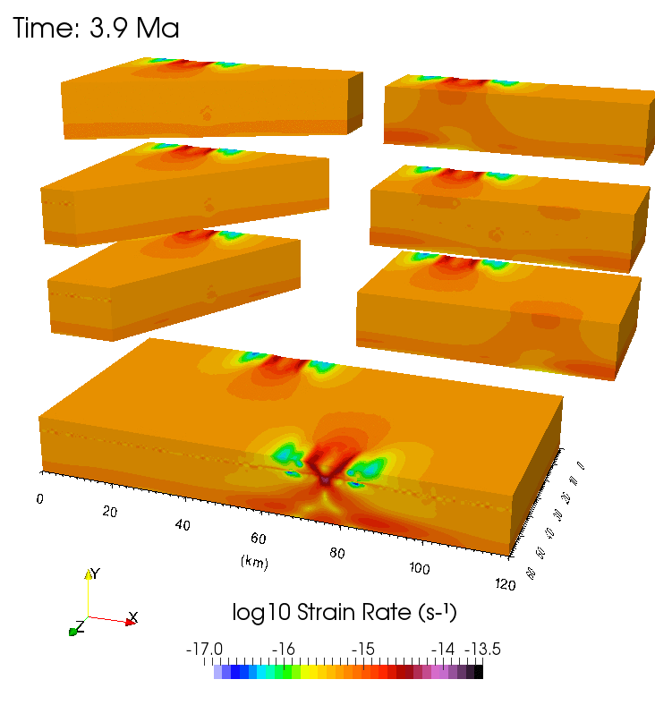
Initial studies using 20 million years of sample geological data have validated the researchers’ models.
They’ve also fashioned their algorithm to improve mathematical descriptions and to sponge less memory, reducing the math’s computational cost while enabling researchers to describe real geological physics. They’ve run simulations on the Department of Energy’s Edison, a Cray XC30 supercomputer, at the National Energy Research Scientific Computing Center without compromising calculation quality.
The team’s software makes another critical advance: It can model processes in three dimensions instead of relying on the two-dimensional models that have predominated over the last 20 years. Previously, researchers studying mantle convection didn’t worry about how underlying changes molded and modified the terrestrial surface.
Adding the third dimension has allowed the team to look at topographical changes over these long time scales to examine changes in the depth, height and overall shape of the crust. Says May, “We don’t force the models to be confined within a rectangular box; we let surface deformation occur.”
So far the team has looked at the East African rift system, which extends from Ethiopia to Mozambique. Continental rifting happens as crust stretches apart and hot magma from the mantle flows upward to fill the breach.
Initial studies using 20 million years of sample geological data have validated the researchers’ models. They start with geological reconstruction, run their models forward to the present day, and then compare the results with observed geology. There are other 3-D geodynamics models, but the team expects its ability to probe these processes at higher spatial resolution will produce more accurate results than 2-D models. The team is applying what it’s learned from these test calculations to compare with actual rift systems.
This new software isn’t useful just for continental rifting. The team is applying it to study subduction, the process where one tectonic plate folds under another plate.
This process is just starting in New Zealand, May notes, so there’s an opportunity to collect data about how these phenomena begin and to understand how they might develop over millions of years. May also shares the software with interested researchers and seven groups have started using it to date.
At its core, long-term geodynamics modeling provides a basic understanding of how Earth formed, evolved and continues to change. May notes that answers to some of those larger-scale questions will help scientists better understand mountain and rift-building processes and some of the stresses that occur at fault lines and lead to earthquakes. Though these long-term models don’t provide near-term information to detect earthquakes and understand seismic wave propagation, some of the lessons learned from them could help with those questions.
In addition, high-resolution models of subsurface physics could help the petroleum industry search for new oil reservoirs. Oil companies have relied on two-dimensional models to locate untapped deposits. But those models have missed locations that turned out to have large reservoirs, Brown says. The equatorial Atlantic Ocean is one such location.
“It’s an interesting example of where 2-D modeling fails,” Brown says, “and people ultimately act on the wrong decision.”